


bancillon

jpfrobert
User
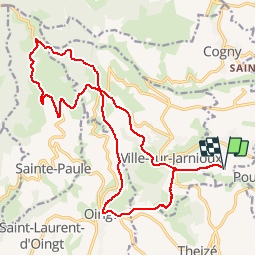

Length
21 km

Max alt
716 m

Uphill gradient
600 m
Km-Effort
29 km

Min alt
350 m

Downhill gradient
597 m
Boucle
Yes
Creation date :
2017-07-25 00:00:00.0
Updated on :
2017-07-25 00:00:00.0
1h52
Difficulty : Unknown

FREE GPS app for hiking
 SityTrail
IGN / Geographical institutes
SityTrail Plus
The world is yours!
About
Trail Mountain bike of 21 km to be discovered at Auvergne-Rhône-Alpes, Rhône, Porte des Pierres Dorées. This trail is proposed by jpfrobert.
Positioning
Country:
France
Region :
Auvergne-Rhône-Alpes
Department/Province :
Rhône
Municipality :
Porte des Pierres Dorées
Location:
Jarnioux
Start:(Dec)
Start:(UTM)
625965 ; 5090837 (31T) N.
Comments